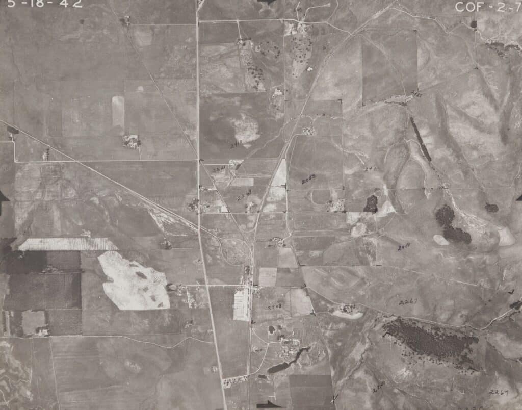
Aerial photography was the primary photography used by Natural Resources Conservation Service (NRCS) conservation planners, soil scientists, and other natural resource specialists in the agency. Conservation planners used the aerial photos to inventory farm, ranch, and forestlands of producers working with NRCS to complete a conservation plan.

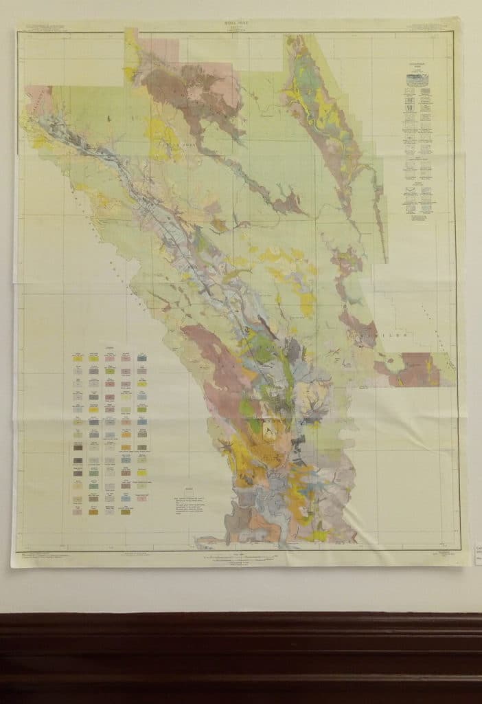
Soil Scientists used aerial photography to inventory and delineate the different soil types on the landscape. NRCS now has soil maps and data available for more than 95 percent of the nation’s counties.

In the 1990’s, aerial imagery used by NRCS changed to digital format, so the hard copy aerial photography was no longer used for onsite inventories. Many NRCS offices maintain the older hard copy aerial photography to track land use changes over time and for historic records of land use and land cover.

Courtesy of the National Resources Conservation Service – 2020

USDA is an equal opportunity provider, employer, and lender.

East

Wild Horse Valley Road History

Wild Horse Valley was named for the large number of wild horses in the area during the 1870s. The first pioneers of Wild Horse Valley Road were immigrants from the Azores. Many became farmers using their land to grow grape vines and grain, with other settlers raising dairy cattle.

In the area then known as “Mountain Valley” in the 1870s, a property owner named Paulus Nelson bought a ranch and is thought to be one of the first people to begin using the name Wild Horse Valley to describe the location. Nelson’s Ranch was sold to the City of Vallejo in 1908 for the creation of Lake Madigan.

Lake Madigan and Lake Frey are located within Solano County. These reservoirs were created to provide water for the City of Vallejo. Frey Dam was built in 1893-1894, but the reservoir was unable to provide sufficient water for the city’s growing population.

In 1965, several parcels of land and ranches north of Lake Madigan were combined to form Wild Horse Valley Ranch, which by 1980 covered 3,500 acres.

Head over to our online catalog to find all of the digitized photos we have in the NCHS collections on the Napa State Hospital.

Napa Area Soil Survey – 1938

Soil types in the Napa Area are complex and diverse, comprised of approximately 49 categories. They are broadly categorized into “upland” and “lowland” soils, with both lighter-colored and darker-colored soils present.

Upland soils are predominately lighter-colored, classified as Olympic, Konockti, Aiken, Butte, and Hugo types. These soils drain easily and are well adapted for wine grapes, prunes, and other fruit that prosper in the Valley.  However, these same soils are not suitable for grain production.

The deeper and more permeable lighter colored soils of the lowlands are represented by the Keefers, Vina, Esparto, and yolo series. The better drained of these soils are utilized for grapes, tree fruits, and general farming and are the most productive soils of the area. The darker colored lowland soils are utilized mainly for grain pasture.

About 39% of the Napa County land surveyed in 1938 was classified as “rough mountainous land.” This topography is generally not suitable for agriculture, and mostly used for forestry and livestock grazing. If cleared of vegetation, these shallow soils erode very rapidly.

South

American Canyon to the boundary between Solano and Napa County.

The territory along the Napa and Solano county boundaries was defined in 1855. At that time, the Yolo County line pushed westward north of Merritt’s Slough.

The Napa-Solano line runs along the Valley’s eastern mountains, which separate Napa Valley from Suisun Valley. The boundary line jogs near the southern property line of Rancho Chimiles and then runs east to the Vacca Mountains, then north again to Putah Creek.

A scrapbook page, showing 4 images of Solano County and the water/bridge over Napa River

Image: NCHS Collection, 2010.56.3, The Loring Scrapbook Collection, Page 76, Solano County.

Visit Calisphere to see a photo from Solano County Library’s collection of the road to Vallejo in the 1940s.

West

To the east of the Napa County border in this aerial is the Stornetta Dairy complex, which served the communities of Napa, Sonoma, and Solano Counties for over fifty years. However, the family business was founded earlier when Louis Stornetta, a Swiss immigrant, moved to Sonoma County in the late 1880s.

The Stornetta family had moved to the location at the intersection of Route 12 and 121 around 1917 and began making home deliveries to Napa and Sonoma in the early 1930’s.

In 1976, Louis’ grandchildren, Charlie and Al Stornetta, who carried on the family business were recognized as outstanding dairymen of the year. By the 1970s, Stornetta’s dairy complex covered 1,600 acres and employed 55-60 people year round and was producing more than 8,000 gallons of milk per day.

In 1977, Stornetta Bros. Dairy partnered with Petaluma’s Clover Farms, and remained the only bottling plant for Clover-Stornetta up until 1991 when the dairy closed.  In the Nuns Fire fire of 2017 The dairy was destroyed and today only the remains of the steam engine and building foundations remain.

Land Case

Bunya Bunya (Araucaria bidwillii)

Many of the trees still growing at Fuller Park were planted as part of the original arboretum in the early twentieth century. The cone and seeds here are from Fuller Park’s Bunya Bunya (also called False Monkey Puzzle and Bunya Pine), a native to Queensland, Australia. This tree can grow to 140 feet, and the cones can weigh up to 40 pounds. Bunya seeds can take months to germinate, staying dormant until optimum climate conditions are reached, but trees are hardy once they have matured. Bunya trees can live for about 500 years.

Northwest

The road crossing through the middle of this aerial is Petrified Forest Road, leading from the Petrified Forest in Sonoma County, over and down the mountain to Calistoga (Just off view on the top right section of this photo).

The Petrified Forest has the largest petrified trees in the world. The once mighty Redwood trees were buried in volcanic ash from Mount St. Helena and over several thousand years mineral-rich water percolated through the volcanic deposits, saturating the trees organic tissues turning them to stone.

Robert Louis Stevenson described the forest in Silverado Squatters1883, “…a great redwood, seven feet in diameter, that lay there on its side, hollow heart, clinging lumps of bark, all changed into grey stone, with veins of quartz between what had been the layers of the wood.”

In the late 1800s, Charles Evans lived on the land and identified one pine tree along with the redwoods. The Petrified forest has been maintained as an attraction by the Bockee family since 1912, when it was purchased for $14,000. Today, excavation work is continually revealing additional petrified trees in the forest.

More content on thePetrified Forest >

Exhibit curated by Nikelle Riggs and Kelly O’Connor, adapted to the web during the COVID-19 crisis, April 2020.

Photo prints for sale

All proceeds of the sale will go towards future exhibit installation costs at NCHS